Click on the image above to view a PDF of the original article by Randy Crutcher that appeared in OutThere magazine.
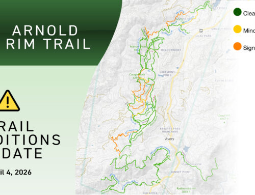
Midway between the deep blue waters of Lake Tahoe and the sheer granite walls of Yosemite Valley, a trail that highlights the treasures of the central Sierra Nevada range has begun to take shape. When fully completed it will traverse portions of the Stanislaus National Forest in an eighteen mile trail starting at the Logging Museum in White Pines and traversing two watersheds, the San Antonio Creek and San Domingo Creek canyons, ending in Hathaway Pines. Side trails will add at least six miles of trail when complete.
Already the trail meanders into creek canyons lined by old-growth trees. It rises to ridges with rocky outcrops, offering vistas of California’s Mother Lode foothill region, the great Central Valley, Mount Diablo, the Mendocino Coast Range, and two Sierra crest wilderness areas.
To date, sixteen miles of the proposed trail have been completed starting at the Logging Museum and ending in Hathaway Pines. But for thousands of full-time local residents—and tens of thousands of part-time residents and visitors—the trail is already a triumph of collaboration, environmental restoration and connectivity.
The Arnold Rim Trail was conceived early in the decade by fourth generation resident Warren Alford, who grew up in Angels Camp, a town fledged in the earliest days of the Gold Rush and now serving as one gateway to Ebbetts Pass National Scenic Byway, a route that bisects the full circle the trail will travel.
In 2006, several local recreation enthusiasts joined Alford in his efforts to promote the vision of the rim trail. They formed the volunteer Arnold Rim Trail Association to assist communities in building and improving local trail systems.
“I think our trail projects have already shown how much people enjoy this area and want to give something back,” said Lonnie Allison, a long-time resident and recreation trails coordinator for the Calaveras Ranger District until 2011 when Jeff Hilson took over that Forest Service position. Jeff did not miss a beat and has continued Lonnie’s passion for the Arnold Rim Trail. The Arnold Rim Trail Association is happy that we report to Jeff now just as we were happy to report to Lonnie. The Calaveras District Office of the Stanislaus National Forest has been a passionate supporter of the Arnold Rim Trail right from the start, and the Arnold Rim Trail would not exist without that ongoing passion from all the staff there.

Years before the Arnold Rim Trail was conceived, an 8,000-acre area known as the urban interface forest had become a zone of contention between homeowners, recreationists and a growing contingent of off-road motorized vehicle enthusiasts, some of whom had created a spider web of trails running willy-nilly over the varied terrain. Clashes between motorized users and homeowners were increasing. Human impact was taking a toll on the land, particularly in sensitive riparian areas.
After the U.S. Forest Service issued environmental impact statement alternatives that were rejected by nearly everyone, the agency ended up supporting a separation of motorized and non-motorized travel—a landmark community agreement. The final decision called for providing high-quality motorized trails in areas furthest from residential neighborhoods and developing trails for non-motorized use in the portion nearest homes. The Arnold Rim Trail became a galvanizing concept for non-motorized trail development and in 2004 was officially documented in an agency record of decision.
At the inception of the Arnold Rim Trail, the Arnold Rim Trail Association and the Forest Service Calaveras District gathered input from local residents and homeowners about their concerns. Association Steering group members worked side by side with local political leaders, young people and retirees all helping realize the dream—one mile at a time, while at the same time carefully addressing community concerns about increased trail use and how that might affect the citizens of Arnold.
The original Chairperson of the Arnold Rim Trail Association Randy Crutcher shared these thoughts as the trail was being conceived, “In my time on the trail, I’ve reflected on how special this area is. I’ve watched a doe deep in the cover of Pacific dogwood emerge with a spotted fawn. I’ve seen the red feathers of woodpeckers glinting in the sunlight as they mark territory on ponderosa and sugar pine, white fir or incense cedar. I’ve stood, transfixed, at the top of San Antonio Falls, mentally grappling with how these sheer walls of stone rising hundreds of feet came to cradle the white horsetail cascading down a hundred feet or more. When I stand at a place called Top of the World, I can fully comprehend why someone gave it that name. Scanning the horizon, I see Mount Diablo to the west, beyond the great Central Valley, and the high country of the Carson-Iceberg and Emigrant Wildernesses, their snowy peaks trailing away to the Yosemite borderland.”
This is a quote from a longer article written by Randy Crutcher.
Article by Randy Crutcher
This article appeared in OutThere Magazine